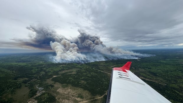
The B.C. Wildfire Service (BCWS) says that the Kiskatinaw River wildfire in the northeast, which has led to evacuation orders and alerts, has the potential to grow in the coming days.
The Kiskatinaw River blaze is burning adjacent to the B.C.-Alberta border south of Dawson Creek, and it covers an area of around 30 square kilometres, down from 46 square kilometres on Friday.
There has been no significant growth on the blaze in the last 48 hours, the B.C. Wildfire Service said in an update Sunday, but they added that weather conditions were dry and windy and could challenge firefighters.
“There’s a slight chance of light rain, but any precipitation is expected to be minimal and may not significantly impact fire behaviour,” the service wrote in an update.
“There is ongoing potential for increased fire activity and further growth in the coming days.”
The wildfire has prompted an evacuation order covering roughly 70 people in the Kelly Lake area, primarily members of the Kelly Lake Cree Nation.
Emergency support services for evacuees have been extended by the Peace River Regional District (PRRD), which said in an update Sunday that it was extending support until June 8.
“This decision was made out of an abundance of caution based on recommendations from [B.C.] Wildfire Service due to uncertain fire conditions,” the PRRD said in a statement.
The Kiskatinaw River wildfire is currently B.C.’s only “wildfire of note”, which means it is particularly visible or poses a threat to public safety.
Officials say that firefighters are building containment lines along the edges of the blaze, and directly attacking the fire where possible.
“Helicopters are dropping water in areas where the fire is most active, to slow the spread and make it safer for crews on the ground,” the BCWS says.
The service added that structure protection personnel were on site in the Kelly Lake area, as well as the nearby One Island Lake area.
The out-of-control Kiskatinaw River fire is burning close to the Pembina Steeprock gas processing facility and Highway 52 East, which has been partially closed as a result.
Homes around Kelly Lake — about 80 kilometres south of Dawson Creek and immediately adjacent to the B.C.-Alberta border — were placed on evacuation order Thursday.
The order also covers areas north of Campbell Lake — west of Tent Lake, south of Twin Lakes, and east of the Alberta border.
As of Sunday afternoon, there were 65 active wildfires in B.C., most of which were caused by lightning.